Observation and survey · Tool 3 of 12
Transect Walk and Transect Survey
Follow a systematic route across a landscape to record how soil, water, vegetation, exposure, access and management change through space.
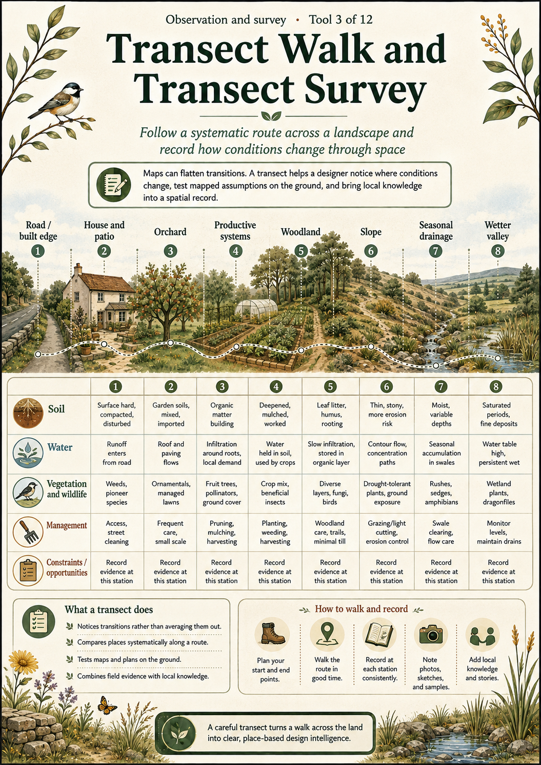
The detailed article and accessible semantic visual below provide the complete HTML text equivalent of the infographic, including its method, cautions and interpretation.
Why this tool matters
Maps can flatten transitions. A transect helps a designer notice where conditions change, test mapped assumptions on the ground and bring local knowledge into a spatial record.
What the tool is
A transect walk is a planned journey through contrasting parts of a landscape. A transect survey adds a defined line, stations or sampling method so observations can be compared spatially or repeated. Ecological and participatory versions share the idea of examining transitions, but differ in purpose, sampling rigour and who contributes knowledge.
Origins and disciplinary context
Transects are established in ecology and participatory rural appraisal. In participatory use, people familiar with the place help identify land use, resources, problems and opportunities. In formal ecology, sampling design must match the population, habitat and analytical question.
The tool at a glance
Conceptual Vila Pinheiro landscape transect from road and built edge through house, orchard, productive systems, woodland, slope and seasonal drainage to a wetter valley.
| Observation row | Built edge | House / orchard | Productive land | Woodland / slope | Drainage / valley |
|---|---|---|---|---|---|
| Soil | Surface and compaction | Disturbance and amendments | Depth and cover | Texture and erosion | Saturation and deposition |
| Water | Runoff entry | Roof and paving flows | Infiltration and demand | Contour movement | Seasonal accumulation |
| Vegetation and wildlife | Edges | Managed planting | Crops and habitat | Layers and signs | Wet-area species |
| Management | Access | Frequent care | Production work | Forestry and paths | Drainage responsibility |
| Constraints / opportunities | Record evidence at each station rather than assigning a single conclusion to the whole site. | ||||
When to use it
Use early in survey, after draft mapping, when comparing upper and lower slopes, or when a community can add place-based knowledge. Choose a route that crosses the greatest relevant variation, not merely the easiest path.
How to use it
- State the purpose and review existing maps.
- Select a route or line crossing relevant contrasts.
- Define observation rows and fixed stations.
- Walk safely with appropriate contributors and record evidence at each station.
- Note elevation, slope, aspect, soil, vegetation, moisture, drainage, shade, wind, access, erosion, wildlife, management and land use as relevant.
- Draw the cross-section and distinguish observation from interpretation.
- Ground-check uncertainties and repeat if change over time matters.
What to record
Record route, direction, date, weather, participants, station position, elevation where available, observation method, soil, water, vegetation, exposure, access, land use, management, constraints, opportunities, photographs and unanswered questions.
Worked example
A conceptual Vila Pinheiro transect could run from the road and built edge, past the house and patio, through orchard and productive systems, into woodland, down the slope, across seasonal drainage and towards the wetter valley. This sequence is a teaching reconstruction, not a claim that Mark conducted a formally named transect.
Connection with Mark’s Diploma practice
Design 03 documents survey, mapping, sector analysis and contrasting site attributes, including built areas, orchards, woodland, slopes, water movement and wetter land. It does not name a formal “Transect Survey”. The related observations therefore provide context only.
Diploma source locators
- Design 03 portfolio edition, printed page 1, PDF page 8: thorough survey and analysis informed the base map.
- Design 03, printed pages 5 to 10, PDF pages 12 to 17: survey method, mapping, sectors and contrasting terrain and resource attributes.
Interpreting the results
Look for transitions, repeated relationships and places where mapped categories fail. A transect suggests questions and possible design criteria; it does not by itself establish hydrology, soil classification or ecological condition.
Limitations
- One line can miss important variation elsewhere.
- Route choice and participants shape what is noticed.
- A walk is not a substitute for specialist topographic, soil or ecological survey.
- Season and recent weather strongly affect observations.
Common mistakes and misuse
- Choosing a convenient route that avoids the relevant contrasts.
- Recording interpretations as direct observations.
- Ignoring local knowledge or allowing one voice to represent everyone.
- Treating a sketch profile as measured topography.
Relationship to other Library tools
Reflection and application questions
- Which line crosses the most relevant variation for your question?
- Whose knowledge should accompany the walk?
- What would require measured or specialist follow-up?
References and further reading
- Food and Agriculture Organization, “Participatory Rural Communication Appraisal: Transect”.
- Food and Agriculture Organization, Land Evaluation, environmental characterisation and transect walks.