Land and Living Systems · 6 of 7
Regenerative Homestead Design
Move from vision and site evidence to a phased regenerative homestead design that connects water, food, energy, buildings, trees, animals, labour and review.
The short answer
A regenerative homestead design is a documented way of improving relationships among a household, its place and the living systems on which both depend. It begins with observation and decision criteria, not a shopping list of technologies. “Regenerative” is a direction to test through evidence, not a label that makes every intervention beneficial.
Vila Pinheiro is used here as a worked example of reasoning. It is not a universal template, and its planned, implemented and measured elements remain explicitly separate.
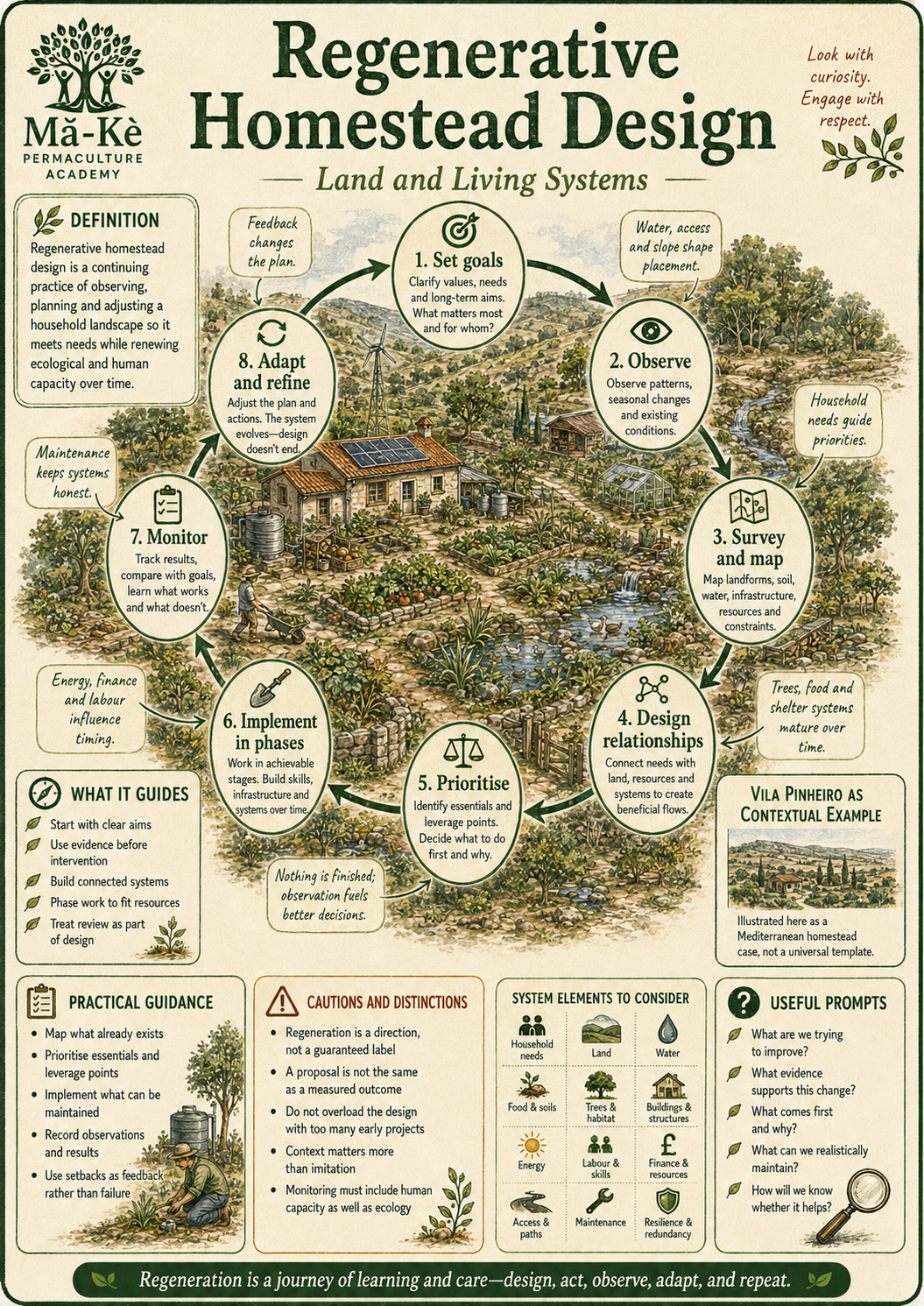
The teaching sections that follow provide the substantive HTML text equivalent of this infographic.
Set a vision and decision criteria
A vision describes the desired relationship with place over time. Convert it into criteria that can guide choices: household wellbeing, ecological condition, water security, affordability, maintainability, learning, safety and community responsibility. Criteria make trade-offs discussable when two attractive ideas compete.
At Vila Pinheiro, Design 03 moved from a broad sustainable-homestead vision to goals for food, energy, water, biodiversity and participation. The design also records financial and maintenance constraints, preventing the vision from standing alone as proof.
Survey before intervention
Build a base map and evidence record. Observe slope, soil, water, vegetation, buildings, access, utilities, boundaries and current use. Add seasonal sectors such as sun, wind, fire, flood, frost, noise and views. Record sources, dates and confidence. A drone image or map is useful only when ground observations and permissions support its interpretation.
Use site observation, sector and zone analysis to organise attention. Follow with PASTE, input-output or needs-and-yields analysis where the question requires them.
Connect systems rather than collecting features
Map how water, food, energy, buildings, trees and animals affect one another. A roof can harvest water and carry solar equipment, but access, loading, fire and maintenance may conflict. Trees can shade buildings and protect soil, but mature roots, crown, water demand and wildfire behaviour shape placement. Animals can cycle nutrients and manage vegetation, but only when welfare, fencing, feed, water and recovery periods are secured.
Trace both useful flows and burdens. Include labour, money, knowledge, replacement parts, waste, risk and permission as inputs. A connection is valuable only when its quantity, timing and quality match a real need.
Prioritise by dependency and reversibility
Stabilise drainage, water quality, structural safety, access and acute ecological damage before adding dependent systems. Prefer small, reversible trials where evidence is weak. Use an action-priority matrix as a discussion aid, but do not allow “low effort” to outrank duties of care or serious risk.
A practical first phase might repair gutters, map water use, establish monitoring points and test one production bed. A later phase can then use observed flows, labour and costs to decide whether larger storage, woodland work or animal integration is justified.
Write implementation and maintenance together
For every action, record owner, sequence, cost range, prerequisite, maintenance task, failure sign and review date. Include specialist design and approval where structures, dams, electricity, wastewater, fire or public access are involved. A system without an accountable maintainer is an unfinished design.
Use seasonal planning. Wet-season earth and planting work, dry-season irrigation and fire preparation, harvest processing and winter repair compete for time. Leave capacity for the unexpected.
Monitor outcomes without manufacturing success
Choose indicators connected to the criteria: water use and storage, ground cover, erosion, soil observations, crop yield and use, animal condition, energy demand, labour hours, cost and system downtime. Record the starting state and repeat the same method.
Design 03 contains early implementation, a timeline and evaluation, while Designs 04-10 develop connected systems and reflection. Where a document says “will”, “aims”, “planned” or gives a future target, this guide treats it as a proposal. A photograph or completed task demonstrates activity, not necessarily the intended ecological outcome.
Vila Pinheiro as a worked example
The site survey identified Mediterranean rainfall seasonality, water flows, wildfire exposure, varied woodland, access, buildings and a household vision. These observations informed zones, sector analysis and a connected grand design. Later designs explored energy, water, food, an Ayurvedic food forest, silviculture, animals and learning.
The transferable pattern is: observe, state goals, analyse relationships, make a bounded proposal, implement in phases, maintain, evaluate and change course. The particular elements and measurements belong to Vila Pinheiro’s context.
Where this material comes from
Design 03 is the principal whole-site record. Designs 04 to 10 add system detail and later reflection. The Academy’s SADIMET and related framework pages provide process context. This guide is an editorial synthesis of those records, not a claim that the homestead has reached every stated target.
Related Library resources
Sources and evidence notes
- Mark D’Cruz, Design 03 - Vila Pinheiro: A Sustainable Homestead, whole-site survey, analysis, zoning, implementation planning and review.
- Mark D’Cruz, Designs 04-10, controlled Diploma sources.
- Mark D’Cruz, Diploma Journey, public overview of the ten-design learning pathway.
Diploma source locators
- Design 03, PDF pages 9-32: vision, survey, sectors, zones, grand design, implementation, finance, maintenance and evaluation.
- Designs 04-09: connected energy, water, food, forest and animal systems.
- Design 10, PDF pages 4-12, 30-45 and 90-99: action learning, integration, reflection and design evolution.
Planning proposals, completed activity and measured outcomes are identified separately throughout this article.